Showing posts with label traffic. Show all posts

Thursday, January 21, 2016

Understanding Metro NY Traffic Acronyms and Abbreviations - Volume 1

Earlier this week, I’m driving up the NJTP, when I come across one of those electronic billboards that relay messages and traffic info which is occasionally correct. It mentioned road closures using the acronym “HRD”. 

I consider myself a pretty well-seasoned NY driver, but it took me a few minutes to realize that the sign was referring to the Harlem River Drive. Well actually it was the TME that was shutting HRD, from the GWB.  Sounds like a mouthful, right?

The point is, sometimes even us locals have a hard time deciphering the dictionary of abbreviations that they use when describing roads. I have collected a glossary of some of the most common ones in case you get stuck in the NY/NJ area.

  • Belt -  the Belt Parkway in the boroughs, turns into the SSP in Long Island
  • BK Bridge -  Brooklyn Bridge
  • BQE -  Brooklyn Queens Expressway
  • Bruckner / 278 -  The Bruckner Expressway
  • CBE – Cross Bronx Expressway, also known as 95
  • CCP -  Cross County Parkway
  • CIP -  Cross Island Parkway
  • CVE- Clearview Expressway, AKA I-295, also the best CIP alternative
  • FDR -  FDR drive spans the east side of Manhattam
  • GCP -  Grand Central Parkway
  • GSP – Garden State Parkway
  • GWB (UL and LL) – George Washington Bridge (Upper level and Lower level)
  • HHP / Hen Hud Park – Henry Hudson Parkway
  • Holl -  Holland tunnel
  • HRD -  Harlem River Drive
  • Hutch – the Hutchinson River Parkway
  • JFK -  JFK Airport
  • JRP -  Jackie Robinson Parkway
  • LGA -  Laguardia Airport
  • LIE / 495 -  the Long Island Expressway
  • MDE / Deegan / 87 – Major Deegan Expressway, also know as the Thruway or I-87
  • MSP -  Meadowbrook State Parkway in Long Island
  • MT Tunn -  Midtown Tunnel
  • NJTP -  NJ Turnpike, also known as I-95
  • NSP -  Northern State Parkway in Long Island -  turns into the GCP once you hit queens
  • OBC / 440 – OuterBridge Crossing
  • OP - Ocean Parkway
  • Pal -  Palisades Parkway
  • QB bridge- Queensborogh Bridge
  • RFK -  RFK or Triborough Bridge (It’s the same thing)
  • RMP – Robert Moses Parkway. You only need this if you are going to the beach
  • SAG -  Sagtikos Parkway
  • SMP / Saw Mill -  The Saw Mill River Parkway
  • Sprain / SBP -  the SprainBrook Parkway
  • SSP – Southern State Parkway, turns into the Belt in Queens
  • TNB -  Throgs Neck Bridge
  • TZB /Tapp -  The Tappan-Zee Bridge
  • VNB – Verrazano-Narrows Bridge
  • WSB -  Whitestone Bridge
  • WSH – West Side Highway spans the east side of Manhattan
  • WSP- Wantagh State Parkway


Monday, March 16, 2015

Tolls going up. Again. Effective March 22nd

Once again the MTA is raising tolls on all of the river crossings in Metro NY.
Most crossings are going up about .50 cents to a dollar for cash payers, and slightly less for EZ Pass.

The new rates go into effect at 2 am ET on March 22, 2015.

Passenger car toll increases:
Throgs Neck / RFK Bridge /Midtown Tunnel 
(Cash / EZ-PAss)
$7.50 / $5.33 increased to $8 / $5.54
Verrazano Bridge (one way tolls) 
$15 / $10.66 increased to $16 / $11.08

To put this in perspective of inflation, I started commuting in about 2005, 10 years ago. At that time, the toll rates were $4 each way for the major crossing, double that for the Verrazano. That means in 10 years, we have seen a 100% increase, doubling the toll rate at the crossings. More information here.

Offical rates and more info on MTS' website here:
 http://web.mta.info/mta/news/hearings/2015FareTolls/FaresBT.html


Wednesday, July 16, 2014

UPDATED: Top 10 Survival Tips for the LIRR Strike


Update: A deal was struck, and the strike is off for now...

The L-I-R-Rmageddon is upon us, and it’s going to be bad. For those NY’ers who don’t think this is going to affect you, think again; subways are going to be packed, and parking will be nonexistent. For us on Long Island, the traffic will be horrendous.  At this point, I guess about a 90% chance of this happening, unless some miracle talks happen at the midnight hour Saturday night.

Your preparations should have started already. However, if they have not, check out the below tips and resources to get a jump on planning.

Tuesday, July 15, 2014

My Nightmare Commute vs. The Most Popular Traffic Apps


Who would have thought 10 years ago, we would be able to surf the web, text our significant others and get real time traffic data all at 80 mph while at an unsafe following distance?

With the rise of FM traffic data and crowdsourcing, a slew of apps are available to commuters looking to get a real-time handle on what lies ahead for their commute. I tested a few of these apps to see which ones work the best, but also offer an interface that doesn't distract and can be used without taking my hands off the wheel or eyes off the road. I used this test to supplement my default traffic Device, Victoria, who is a Garmin Nuvi with live traffic data (which is right maybe half the time). She has a really bad habit of telling me to pick a route, and then turning into a solid red line as I am already in a dead stop. Hence my need to use a traffic app. 
This is My GPS's very accurate prediction of traffic
incidents. Red Lines indicate traffic incidents.
 This photo was captured during a
five hour standstill on the Cross Bronx the other night. 

This test is being done on a brand spankin’ new Samsung Galaxy S4, with a Verizon 4G network. (it was being done on an older S4, but I… um…shattered that) I’m using each app for a full week of commuting, so all are used in the same locations. This minimizes the inconsistency between load and processing times.

I tested four of the most recommended traffic apps to see which one could best handle my commute through Long Island, 3 Metro NY boroughs and New Jersey. Bonus points were also awarded for the couple of family road trips in between.

First: Waze
Welcome-  you just became a “Wazer” is the cheerful way this program greets you upon its initial launch. It pushes hands-free operation and social networking, and a sense of community within the app. It starts me out as a “Baby Wazer”. Not sure how my ego feels about that. The avatar assigned to me of a small ghost-looking thing with a pacifier in its mouth.

Waze is by far the most popular traffic app used today. You see a lot of Wazers on the road as you drive, and I found myself frequently wondering which of my fellow commuters were the Wazers. On the way back from a recent client meeting in another state, members of my team were also Wazers, and we used the app to dodge cops and pick the best route from Pennsylvania.

Almost anywhere you go, you can see your
 fellow Wazers with the App, making this
 a more social experience.
Overall, this is the one traffic app I continuously find myself consulting, even after I have since deleted the others off of my phone. The data is crowd sourced, so you get a truly accurate picture of how traffic is moving ahead of you. FM traffic data can sometimes be spotty, but by using actual real time data from other motorists, you can easily tell exactly how long a delay is going to last, and how fast you will get through it.

But the best feature of Waze isn't actually the traffic data, it’s the Cop spotting feature. Whether responding to an incident or setting a speed trap, a police presence is clearly indicated on the map, and the driver is altered when approaching said officer. Sure, its only right about 60% the time, but it is extremely useful for long-distance car rides, and adds a sense of security a radar detector can't match.

The interface on WAZE makes it easy to quickly
 report  road hazards. If i were a cop setting a
speed trap, I would also be using this app to tell
when my position was compromised. 
Another interesting thing about Waze is the way it looks to socialize and gamify traffic data. Users are rewarded for driving miles and reporting incidents with points. These points level you up.  Besides a personal sense of accomplishment, there really isn't a benefit to leveling up, but I’m sure your fellow Wazers on the road think you look cool when your icon gets a sword in the further levels.

But there is no such thing as a perfect app. My one biggest complaint with this app was the amount of driver involvement that was required to effectively operate it. its worth noting that simply waving a hand in front of the screen activates a hands free mode on Waze, which is certainly helpful, but I still have to take my eyes off the road for a bit longer than other apps to get the info that I need.

By waving your hand over the screen, Waze lets
you enter a hands free mode where you can command the app
Otherwise, the Graphical user interface (GUI) could use a little work. Its bright and contrasty, but I often times had a hard time distinguishing upcoming traffic. For example, I could see there was an ominous dark red line ahead of me, but I could not tell if it in my general direction or not. Also, it’s a huge battery suck. I start out my day with 100% battery, and I’m at 65% by the time I make it to work, which just isn't realistic.
Overall, this app is highly recommended, but I also recommend that you need to have your phone both mounted in a visible, easily accessible position and plugged in continuously if you plan to use it.
Summary
The GUI holds a lot of information, which can be
 difficult to discern what direction of travel the hazards are affecting.
·      
     Pros
o   Crowdsourced, most reliable data
o   Calls out cops
·         Cons
o   Interface / GUI need some work
o   Requires a lot of driver involvement, and it’s a ranking system, which I think makes people take their eyes off the road
o   The interface isn't the easiest to tell you which route to take. For example, when I approach the Cross Island or the Clearview from the Grand Central or Throgs Neck, I use traffic data to tell me which way to go and save a few minutes.
o   Huge battery suck. I can’t start my workday with a 65% battery.
o   The best way to use this app is mounted on a windshield, and plugged in
Second: Google Maps
Google maps is the by far the quickest and easiest to use. It’s got very straightforward controls, and has a turn by turn navigation feature built in which is also very helpful.  What Google lacks in features, it makes up for in its simplicity. The GUI is clean and straightforward, and tells you of incidents.

It’s interface is so straightforward though that it lacks some of the critical data. For example, since it does not have movement data, you can’t tell if the dark red line is stand-still traffic or just traffic moving under 20 MPH, which is par for the course for the Cross Bronx.

This app does although win when it comes to distractions. It loads very fast, and is super responsive. It can easily be operated with one hand so I don’t have to take the other hand off the wheel, and I typically don’t have to take my eyes off the road to wait for it to load data.
Google Maps traffic feature is very
 straightforward, and likely already on your phone.

The traffic data although is the same sourced FM traffic data and Travel time network info that the other apps use, so it lacks the real time updates of WAZE. Its usually pretty reliable though, but I cant wait until they start mining a crowdsourcing option for this app.
·        
      Pros:
o   Clean GUI is easy to use
o   Fastest response
o   Least battery drain
o   Navigation option
·         Cons
o   Doesn’t tell you about cops or road hazards
o   Same data as everyone else
o   Vague colors to indicate speed
o   Second highest data consumption
Third: Sigalert
Sig alert has a great desktop feature (sigalert.com) for sourcing traffic data, which I often check before I leave for work. I just wish the app were as good as the desktop website, as it tells me average MPH with a full view of all traffic cameras.

The same traffic cameras are at the heart of the Sigalert app, which pop up as icons on the map interface for the program. It's traffic camera database is the programs most useful feature.

the gradual color scheme in Sigalert makes it the easiest to
 pick a route at a glance, without ever confusing travel direction
But overall, the interface to this program is just way to slow to realistically use while driving. On a 4G network it crawls to keep up, and the traffic cam data refreshes slowly and has such a slow frame rate, it isn’t as useful as it could be. Zooming in and out is also very erratic, and typically doesn’t land on the view you want. But as a positive note,  unlike the other programs, this app uses gradual colors from green to red to indicate traffic, so there is never any confusion about which direction has congestion or is free-flowing.
The traffic camera database is huge, and clicking
 any one of those camera icons will bring up the feed.

You also have the option to create a free account with Sigalert, and input route data to customize the app.
·         
       Pros
o   Traffic cam database
o   Color scheme means you never get confused about the flow of traffic
·         Cons:
o   Clunky interface requires a bit too much attention to be functional
o   Slow response
·         Fourth: Inrix
Inrix's home screen makes it a bit difficult to tell
local conditions, while red dots indicate alerts
·         Finally there is Inrix. This app has high aspirations, and tried hard to be the best of all of the programs available. Unfortunately, the execution doesn’t really work all that well. Two main screens make up the interface. The default screen is all of the data around you, including a zoomed too-far-out local map, alerts and traffic cams. The secondary interface which you can access is an interactive map. By default it’s a 3D view which can be hard to read, so I opted for a less extreme angle which gives a nice view of traffic. But the map itself looks like a re-skinned version of Google maps, be it although less user friendly. With its latest version, the map interface is almost as fast as Google’s, and it has a nice “Follow me” feature to help ensure a perfect view.

When zoomed into the map feature,
 Inrix warns you of alerts with
an easy-to-navigate view
Apparently, the data in Inrix is also crowd sourced, as it usually tells me there are about 20,000 Inrix users around me at any given time. The only thing is, I don’t see the data from these people anywhere. The app gives the option to report issues, cops and other alerts, but I have never actually seen this data presented anywhere on the map. So while I don’t doubt it’s there somewhere, it’s buried too deep to be able to locate it while operating a motor vehicle.

But the cons to this program made its test a bit tedious. First, it destroyed my phones battery, taking me down to about 50 percent each day for my morning commute. It’s also a massive data hog, eating up nearly ten times the data of the others apps at about 65 MB worth. The only explanation for this I can think of is that the traffic cam data loading is very heavy.
the maps feature looks a lot like
 Google's, and is similarly responsive.

By swiping down, users can see more relevant
 information about hazards around them
Overall, despite its great all-around features, it falters in the fact that it just offers too much to be able to use effectively

·         Pros:
o   Best options for viewing – once you get out of the standard view into the map view is when it becomes really useful for route planning.The birds eye view is at an extreme enough angle so you can see what’s ahead and still navigate.
o   Has all the bells of whistles of the other apps, if you can manage to find them

·         Cons:
o   Traffic cams are easily accessible. This would work well, but the refresh is so slow, it doesn't apply to metro NY traffic, where cars can be bumper to bumper, but still moving at a good clip.
o   So I thought Google maps was a battery suck -  this took out half of my battery before I even got to work
o   No alerts for cops or accidents
o   Holy hell what a data hog -  for one round trip, Inrix used 62 MB of data.

Download: Google Play


Conclusion:
The bottom line is that traffic apps are helpful, and a must-have for any hardcore commuter. There are many options out there, but these four represent the most popular. I would suggest trying them all and using the customizable interface to see what works best for you particularly. But please remember to drive safe, and don’t be one of those people who causes an accident because they are browsing on their smartphone to try and find the accidents. I would also recommend investing in some sort of dash mount for a phone and a car charger if you plan to make one a part of your everyday commute.

After a fulls weeks usage, Inrix turned into
a huge data hog, with Google maps a distant second.


Tuesday, June 24, 2014

Why July 20th Should Matter to Everyone in Metro NY and Long Island – #LIRRmageddon!

Mark your Calendars for July 20th - if you aren't concerned about this date and you live in Long Island and Metro NY, you should be.  This might be the day when MTA workers for the Long Island Rail Road (LIRR) are planning to walk off the job if contract negotiations fail. You heard it here first, I'm going to dub this “LIRRmageddon” (it sounds better when you say it aloud, trust me.) 

Some of us may recall the weeks after hurricane Sandy when the LIRR was off line, and the hours added to the average commute. When the LIRR is shut down, tens of thousands of daily riders will be on the road, further adding to already congested roads. The MTA is asking employers to ease restrictions on working from home, and suggesting people take vacation time during the strike. Regardless, we are all screwed if the strike goes through.

I personally work from NYC at least one day a week, and drive to NJ the rest of the week. Driving to the Manhattan will not be an option, as parking will be at a premium and the traffic in the Midtown Tunnel and other crossings will make the NJ Bridgegate look like the final lap of a Nascar race.

Through public announcements and leaflets handed out to riders, the MTA has outlined a contingency plan which calls for the following: (According to a Newsday article from today)
  • ·         Work from home or take vacation time
  • ·         Organize carpools
  • ·         Ask if employers will provide transportation or reimburse for hotels, or work off-peak hours
  • ·         Share housing with family and friends
  • ·         Park and ride lots will be set up at key points going into Manhattan including stadiums, where commuters can take a bus or a subway into the city
  • ·         Get ready to sit in a lot of traffic. (I added that one in)

Now my personal opinion from a communications professional’s standpoint: For a system that’s rife with corruption, disability fraud and nepotism, the general public has all but lost patience with the workers union, and they are having a hard time gaining public support for their cause. They were offered an 11% salary increase, but demand 17%, well over other state MTA workers. They are also fighting the pension contribution rise to 5.2%-which is surprising considering the pension and disability systems are huge black holes where public funding goes to die. These funds are passed on to the riders as fare increases, which already top $300 for a monthly ticket. As the public continues to see 401K’s collapse and fees increase, the idea of a full pension with minimal contribution is a pipe dream that many see should be reserved only for the cops and firefighters who put their lives on the line on a daily basis. Additionally, the abuse of overtime and an average salary of more than $83K yearly has the patience of many commuters running thin. The facts also show that until now, workers did not pay for healthcare coverage, which costs the average worker thousands of dollars a year. (Facts quoted from NY Post article Dated 6/8/14)

I give this strike about a 60% chance of happening, which is too high of a risk to not make the appropriate preparations now.


The workers can be seen currently engaging in an unchecked communication plan of actively engaging readers in news article comments and picketing; which, without proper messaging will only yield negative perception for them in the long run. But that doesn't matter, as the public gets no say in this matter because this is now a federal issue.

Monday, April 21, 2014

Today I bypassed the Cross Bronx traffic with this one weird trick. You’ll never believe how….

Before reading any further, yes that headline is indeed a satirical play on the current crop of Buzzfeed headlines. But seriously, today I tried something new. On approach to the Throgs Neck, the Traffic Time sign told me the Cross Bronx / 95S (CBX) was going to be over an hour. The 278/87 route on the other hand was 20 minutes. I have never attempted this way before, because looking at my map it just did not make sense. It seemed to be miles out of the way, and dip into the Bronx. Figuring I had nothing to lose, I exited right before the wall of brake lights, and hoped for the best.


And wow, that was easy. The lesson learned today is that if the CBX sucks, hop on to the Bruckner/287 West, and take that a few miles to 87N/Major Deegan. The signs won’t say GWB at first, but just keep following them, and it will drop you off much faster than taking the Triborough bridge route. I have been driving the same route  for nearly 7 years, and was pleasantly surprised to finally find a viable CBX alternative.

Sure, its a couple miles out of the way, but taking the Bruckner/278W instead of the CBX can save you a lot of time

Monday, April 14, 2014

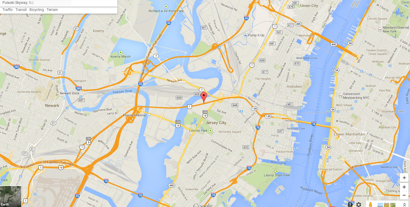
The Pulaski Skyway Closure and What That Means for Your Commute


The Pulaski Skyway is one of the main thoroughfares into Jersey City and Manhattan. It’s a bridge that carries traffic from Route 1 and 9, and also serves a large portion of traffic exiting 95 (NJ Turnpike) on their way to and from the city. Starting this week, it’s going to be closed for two years. Expect a lot of traffic on surface streets as well as alternate routes as commuters try and make their way into the Holland Tunnel.

The bridge opened in 1932, and is in the final phases on a one billion dollar restoration that has been going on since 2007, and is slated to be completed in 2016. On this first weekday of closure, traffic has been light. This is most likely due to the impending Jewish Holiday, as well as the majority of schools not in session for spring break.  Expect about 2-3 weeks to get into a groove if this is your route, as commuters will get used to the new route options and detours


The most impacted areas are going to be as follows:
  • i95 N around Newark airport
  •   i78 will likely serve as the main bypass for many travelers; its only a few miles out of the way, and is wide enough to handle a good amount of extra traffic.
  •  Another traffic choke point is going to the rt. 1/9 bypass, AKA, Lincoln Highway.
  •  Outbound from Manhattan, commuters can expect heavier loads leaving to and from the Lincoln Tunnel as it hooks up with 95.
  • Coming down from the north, Rt.3 and 495 will see a lot of extra volume as commuters use the Lincoln Tunnel and go downtown via Manhattan surface streets.
  •  This will also cause additional delays on the West Side highway between the 50’s and downtown. Buckle up, the west side is going to be a mess for a while.
  • On the bright side though, Holland Tunnel traffic inbound is likely going to be significantly lighter until the pattern works itself out.

My route picks:
·         As always, use your traffic apps and listen to AM 88/1010 Wins for the most updated traffic, as conditions change, accidents happen and traffic flow varies greatly with the times of day.
·         Don’t go near the Lincoln tunnel
·         If you are coming from the north, use the GWB, and shoot down the Westside highway for downtown Manhattan access. Expects a mess down by the 30’s. If you are really ambitious, go a little further, and hop down the FDR to head downtown.
·         You might be tempted to take the Verrazano/ Goethalls up the Gowanus (278) to make it into Manhattan. I wouldn't do that due to the Gowanus’ propensity to back up. The belt isn't much better. Use this route only for queens, SI, Brooklyn and LI travel
o   You can also take 95 to 278, and take rt. 440 N to hook back up to 78.
·         The best route for now is probably going to be i78 for most weekdays.

·         A lot of this also depends on the signage they have up and how it affects those who aren't familiar with the territory. For weekends and Fridays, the Rt.9 bypass is going to be a good alternative to the i78 traffic that most weekend travelers will likely be directed towards. 

Thursday, September 5, 2013

Remember That Day I Was Mistakenly Targeted for a Criminal RICO investigation? Fun Times Indeed…


An interesting thing happened to me yesterday. Its early in the morning, about 6:45 am, and I’m stuck in gridlock on the Northern State Parkway. It’s the week after Labor Day, and traffic has returned with a vengeance.  In my rearview I see an unmarked Crown Vic, and I think nothing of it. Obviously, 4 mph is well below the posted speed limit, so I go on about my business.

Traffic started moving again, by the time I made it the Queens line, there is a marked NYPD unit about three cars back. I’m taking it easy, so I pay no attention to that car. I merge with grace onto the Clearview, (because the Cross Island is for suckers) and accelerate into the flow of traffic. Then there is another unmarked behind me, a blue Crown Vic.

At this point I’m thinking to myself, “wow, big police presence on the road today, they must be going after people texting or something.”

A few miles pass, and then a Marked NYPD Charger is on my ass. I mean to the point of giving me a V8 enema, this guy is not backing off. But I’m doing the speed limit, so I’m more confused. Obviously, this guy wants me to see him, and I see him in my rearview, on his radio, running my tags.

We make it to the Throgs Neck bridge, and he suddenly jumps two lanes and takes the ramp on the right to Willets Point Blvd. when he backs off, I see another unmarked unit behind him. This one is a blue Crown Vic, and he is staying about 3-4 cars back to my right.

Now I’m starting to sweat. I got a couple of points from a previous run-in, and I do not need any more. Again, I’m not doing anything wrong, so I am very confused, but the mere anticipation of getting pulled over makes me anxious.

I am now going over the Throgs Neck. I make a bee-line for the left lane to avoid the CIP marge, and the blue Crown Vic does the same two cars back. This pattern continues all the way to the tolls. I pick a lane, and go through the EZ Pass lane, ready to merge onto the Cross Bronx.

BAM! Out of nowhere, a marked Impala NYPD unit is on my ass with lights flashing. Seriously, I had no idea where this guy could have possibly been. “He can’t really be pulling me over, can he?”  I slide right a lane. He follows. Shit. I manage to pull over, on the left side of the road closer to the 95 North split.

I get out my license and registration, and wait. A jolly old NYPD patrolmen resembling Santa Claus with a Glock approaches up to the car. His 9mm is holstered, but his hand is on it, which I assume is typical protocol. My hands are where he can see them, and the exchange is respectful and polite. He asked me for my license and registration and insurance. This is odd. In all my years of getting pulled over in NY, I have never once been asked for Insurance information. He asks me “is this your car?”

“yes, it is” I reply, cool as a cucumber as a slide off my sunglasses in my best David Carusoe. Not my best moment. 

“Are you sure it’s your car?” he asks again, and I nod. At this time, I did not realize the odd phrasing of this question, or why he was asking. So I ask, “What seems to be the problem officer?” I had to yell a little bit, because now there was a helicopter over us. Probably nothing right?

Digressing for a moment, we all ask this when stopped. You could be riding dirty at 80 MPH through a school zone with a pina colada in one hand, yet still ask the question. You always know why you are getting pulled over, but in this instance I was genuinely perplexed.

 “Your windows are tinted” he proclaims. “State law says there needs to be 70% light transmission.  Do you think this window lets that much light in?” I don’t know why it took me a moment to answer. I guess I got distracted when glint of light caught my eye, which vaguely resembled a sniper on the overpass about 300 yards away.

“I don’t know.” But yeah, I actually knew.  I purposely put on 20% tint the whole way around, because having a sleeper with no tint is about as cool as Saved by the Bell: The College Years.

He said this is 17%, and proceeded to go back to his car. He was in there a long time. Despite his being nice, and the multiple stickers on windshield from various law-enforcement buddies, I  still got an equipment ticket. My last car had 10% tint and I drove it for 5 years. This car has 20%, and I have been driving it about 5 years. I have never been pulled over for a tint violation.  

The ordeal is over. We exchange pleasantries, and now I have to merge hard across six lanes of morning rush hour traffic onto the Cross Bronx. I settle into the middle lane and begin to ponder what just happened.

 First of all, three units do not tail you for an equipment violation. Therefore, I am now under the assumption that a car similar to mine had been used in a crime, and they were checking me out. They needed to pull me over. That’s fine, making the streets safer, etc. now I am also realizing perhaps a murdered-out Maxima might be starting to be a little ghetto. I’ll address that another time.

Cruising along, rocking out to come classic A7x on the radio, and WTF THERE IS ANOTHER GOD DAMN UNMARKED UNIT BEHIND ME.

Remember that scene in that 90’s mafia movie, I think it was Good Fellas, where the guy looks outside his windows and he spots helicopters. Then the chopper is following him all day, and he is paranoid. And eventually it comes to pass that he was right and they totally were watching him? Well this is exactly how I’m feeling right now.


Now here’s where things get really weird. The NYPD unit pulls off about 1/8 mile from the GWB, and is immediately replaced; I kid you not, with an grey unmarked Crown Victoria interceptor unit with Jersey Tags. This is significant because this now means whatever these guys are trailing me for goes beyond state lines. I don’t know if was a sheriff, Fed, or Jersey trooper, but odd none the less.

I make it work without incident. Sure, some odd things happen to me during the day; my webcam liked to turn on by itself, “The CIA” asked me to friend them on Facebook, and there was some dude bird watching all day outside my office window. So nothing out of the ordinary.


I start on my way home. I was a little late, because some new I.T. guy at my company wanted to look at my computer and phone. Nothing weird about that.  I’m on the NJ turnpike heading toward the GWB, and out of the corner of my eye, I spot one of the new Ford Taurus unmarked units. These guys are stealthy. The only way to really tell they are cops is by looking in the grill to spot the tell-tale light array. I go Lower Level. He follows. I go CBX. He follows. He pulls ahead of me and takes the Throgs Neck. I take the Clearview. He shadows me. Northern state. Right behind me. Wantagh. This is getting creepy.

So now I’m sure that something is going down, so I call my buddy in the NYPD and ask him what’s up. He runs my license, runs my plate, and my information to look for possible APB’s.  It take a while, but he tells me it all comes back fine, and that I’m just being paranoid. That’s a relief. But then I also realize maybe he actually can’t tell me what’s going on.

It still troubles me though that the unmarked Taurus got off at my exit, and peeled off right before my street. I swung around that big, unassuming van parked on my curb, and pulled into my driveway, happy to be home. 


So that’s my story. Hopefully this is where it ends. However, for the CIA, FBI, RICO investigators readings this (and I know you are….) Can you please do me a real favor and see who isn’t cleaning up after their dog on my lawn? Much appreciated, XoXo.


Monday, August 19, 2013

OK GPS, now you're just mocking me

This shot is the Inbound approach to the GWB, slowed to a bumper to bumper crawl Thursday. Apparently my GPS thought it was an opportune time to develop a sense of sarcasm. 

Friday, August 9, 2013

GW Bridge Construction Alert, and How to Avoid It


As of August 5th, expect delays at the GW Bridge. 

The George Washington Bridge is undergoing a multi-million dollar renovation project to repair the aging upper level. Nighttime work has most lanes of upper roadway completely closed. 

This week, Jersey bound lanes will be closed from 11 pm to 5 am, and starting next week inbound lanes will be closed at the same times. As usual, residual morning delays may occur until 6-7 am. They will adjust lane closures accordingly with Yankee games.


What does this mean? At night, the CBX Westbound / 95 N is going to be a nightmare . The Deegan will be slightly better. After next week, expect inbound delays of up to an hour. Lower level recommended if you have to take the bridge. Upper Manhattan is going to suck for the rest of the month.

My suggested night time route is to take one of the tunnels from in town, or the Verrazano / Goethells combo if coming from the south. For all other times of day, my advice remains to always default to the lower level unless you hear reports of massive Deegan delays or a Yankee game.

Tuesday, June 11, 2013

Escort Announces New Passport Max Detector and an End to False Alarms


Today I was cruising along I-95 south, coming out of the GWB. Right after the 80 split, I get passed by an Accord hauling ass. I slow down, because I know better; A Jersey State Trooper always camps out on the left, waiting to pounce on the unaware speeder coming around that bend. Even though he is right out in the open, by the time the Honda saw him, it was already too late. Speed traps down here aren’t always on the side of the road, sometimes they stalk congested traffic in unmarked units as well, and even use the occasional air unit. I have yet to find a detector that works effectively in metro NY. It’s a challenge for any system because the amount of signal interference makes it constantly chirp for false alarm. 

I got news the other day of a new detector announced from Escort, which makes some lofty promises and might be worth checking out. Apparently this device is a bit different because it contains an intelligent signal analysis which reads signals differently to cut down on the amount of false alerts. It also packs in a longer range, and faster response time, so you get that extra split second to hit your brakes if needed.

But back to the guy in the Accord - This radar detector also has access to GPS location technology, so if he had this system, it would have likely alerted the offender that there was always a speed trap here. The “Defender Database” as it’s called also flags the location of speed cams and other threats to provide advance warning.

At $549 it’s a bit of a lofty price for a windshield unit, but it has some nice features such as a customizeable OLED display that flows with your ride’s interior, and displays a wealth of useful information.

See below for press release from Escort

ESCORT Debuts Ultra-Fast PASSPORT® Max™ HD Radar Detector, Powered by Advanced Military Technology


WEST CHESTER, Ohio, June 10, 2013 /PRNewswire/ -- Category leading innovator and holder of over 85% of radar patents,ESCORT Inc. (escortinc.com) raises the radar detector performance benchmark again with the release of its all-new High Definition PASSPORT® Max™ radar & laser detector. Using advanced military technology, PASSPORT Max™ delivers high definition performance with ultra-fast signal processing and unprecedented noise filtering. 
“Our new PASSPORT Max™ is the best detector we have ever made," said John Larson, ESCORT President and CEO. 
True Digital Signal Processing allows PASSPORT Max™ to achieve ultra–fast processing speeds, unprecedented range reporting and DNA intelligent signal analysis for the ultimate in alert clarity. 
PASSPORT Max™ establishes never before seen performance levels for radar and laser ticket protection. 
By designing PASSPORT Max™ around advanced military high speed digital signal processing (DSP) technology, ESCORT engineers have given PASSPORT Max™ the ability to search for threats fifty times faster than any other radar detector.  PASSPORT Max™ literally scans for radar threats faster than 'the blink of an eye' (a human eye blink takes several hundred milliseconds while PASSPORT Max™ scans signals more than twice as fast).  
This dramatic increase in speed delivers a corresponding leap in detection capability and range. 
In an advanced new product test overseen by the category's leading authority, Speed Measurement Labs (SML), PASSPORT Max™ established three new benchmarks for the detector category.  Setting new records for longest range, fastest response time and greatest sensitivity, PASSPORT Max™ displayed the best performance that SML had ever witnessed. 
"In 30 years of impartial testing, we haven't seen this level of reporting range or immediacy of alerts by any other radar detector," said Speed Measurement Labs President and CEO.
In one test, physicists used an extremely low powered radar gun to test sensitivity. Typically, detectors do not see this source beyond the one-mile mark but PASSPORT Max™reported the same source from beyond seven miles! 
In another SML test, PASSPORT Max™proved its extremely fast response time by alerting to measured test signals more than four times faster than any competitor detector ever tested. 
To determine how far PASSPORT Max™could alert, SML engineers used the longest physical distance on the range. PASSPORT Max™reported every gun, every signal, to more than fifteen miles (standard detector testing for the SML range ends at nine miles as detectors predictably cannot pick up such weak test signals). PASSPORT Max™simply reported alerts from the longest distance ever tested. 
Additionally, high speed military DSP enables the PASSPORT Max™ to process signals with more than an order of magnitude increase in measured selectivity. An order of magnitude translates into a ten-fold increase in performance. This new level of selectivity, or intelligent signal analysis, is similar to the dramatic performance increase seen in forensics when technicians moved from fingerprint readings to the science of DNA analysis. 
PASSPORT Max™ 'sees' the DNA of every received signal, a technology that no other detector possesses. 
For drivers this means an entirely new level of signal information and awareness. PASSPORT Max™ filters the true alerts, those from radar guns, from unwanted false alerts, such as automatic door openers and motion sensors, that competitor radar detectors cry 'wolf' to over and over again.  PASSPORT Max™ reports with an accuracy that exceeds any other technology ever driven.
"...this is the best radar detector ever made," said leading industry analyst, Radar Roy.
PASSPORT Max™ also features a new high definition OLED (organic LED) multi-color graphics display. Drivers can choose up to four different colors for displaying critical driving information such as posted speed limits, over speed alerts, driving speed and more. 
The high speed DSP detector also includes ESCORT's patented GPS Location Awareness technology, which enables PASSPORT Max™ to alert to fixed position threats including red light and speed cameras, major speed traps and future threat technologies as they unfold. 
PASSPORT Max™ includes a mini-USB port for quick connection to the internet for software expansion, data base updates and more. With Internet connectivity, ESCORT engineers can always keep PASSPORT Max™ at the leading edge of detector performance.
PASSPORT Max™ is designed to connect with ESCORT's multi-award winning ESCORT Live™ ticket protection network. ESCORT Live™ helps customers drive smarter by dramatically increasing overall knowledge of their driving environment through threat and information sharing among networked drivers.
"As the category innovator, we simply keep pushing radar detector technology to new performance standards – PASSPORT Max™ establishes a completely new level of driving awareness and protection," said Tim Coomer, ESCORT Product Development Vice-president. "PASSPORT Max™ is the new best-in-class performance with record measured alert speed, record measured range and record measured selectivity for superior performance."
PASSPORT Max™ continues ESCORT's 30 plus year dominance of the radar detector category.
PASSPORT Max retails for $549.95 and is available factory direct. 
For more information on the new ESCORT PASSPORT Max™ HD Radar Detector, ESCORT Live™ ticket protection app and ESCORT's complete line of premium automotive products, visit ESCORTinc.com or, call the company direct at 800.433.3487.

About ESCORT Inc. 
ESCORT Inc. is the leading manufacturer of high-performance radar and laser detectors, the patented ESCORT Live™ real-time ticket protection network, ESCORT MobileTV™, Guardian Alert reverse obstacle detection systems, Entourage GPS-enabled navigation and tracking products, ESCORT QuickStart™ and other Drive Smarter products.  ESCORT manufactures products under the ESCORT, PASSPORT, Max, REDLINE, SOLO, Vector and BELTRONICS brands. The company is headquartered in West Chester, Ohio, with its principal manufacturing facility located in Mississauga, Ontario, Canada.