Showing posts with label NJ. Show all posts

Thursday, January 21, 2016

Understanding Metro NY Traffic Acronyms and Abbreviations - Volume 1

Earlier this week, I’m driving up the NJTP, when I come across one of those electronic billboards that relay messages and traffic info which is occasionally correct. It mentioned road closures using the acronym “HRD”. 

I consider myself a pretty well-seasoned NY driver, but it took me a few minutes to realize that the sign was referring to the Harlem River Drive. Well actually it was the TME that was shutting HRD, from the GWB.  Sounds like a mouthful, right?

The point is, sometimes even us locals have a hard time deciphering the dictionary of abbreviations that they use when describing roads. I have collected a glossary of some of the most common ones in case you get stuck in the NY/NJ area.

  • Belt -  the Belt Parkway in the boroughs, turns into the SSP in Long Island
  • BK Bridge -  Brooklyn Bridge
  • BQE -  Brooklyn Queens Expressway
  • Bruckner / 278 -  The Bruckner Expressway
  • CBE – Cross Bronx Expressway, also known as 95
  • CCP -  Cross County Parkway
  • CIP -  Cross Island Parkway
  • CVE- Clearview Expressway, AKA I-295, also the best CIP alternative
  • FDR -  FDR drive spans the east side of Manhattam
  • GCP -  Grand Central Parkway
  • GSP – Garden State Parkway
  • GWB (UL and LL) – George Washington Bridge (Upper level and Lower level)
  • HHP / Hen Hud Park – Henry Hudson Parkway
  • Holl -  Holland tunnel
  • HRD -  Harlem River Drive
  • Hutch – the Hutchinson River Parkway
  • JFK -  JFK Airport
  • JRP -  Jackie Robinson Parkway
  • LGA -  Laguardia Airport
  • LIE / 495 -  the Long Island Expressway
  • MDE / Deegan / 87 – Major Deegan Expressway, also know as the Thruway or I-87
  • MSP -  Meadowbrook State Parkway in Long Island
  • MT Tunn -  Midtown Tunnel
  • NJTP -  NJ Turnpike, also known as I-95
  • NSP -  Northern State Parkway in Long Island -  turns into the GCP once you hit queens
  • OBC / 440 – OuterBridge Crossing
  • OP - Ocean Parkway
  • Pal -  Palisades Parkway
  • QB bridge- Queensborogh Bridge
  • RFK -  RFK or Triborough Bridge (It’s the same thing)
  • RMP – Robert Moses Parkway. You only need this if you are going to the beach
  • SAG -  Sagtikos Parkway
  • SMP / Saw Mill -  The Saw Mill River Parkway
  • Sprain / SBP -  the SprainBrook Parkway
  • SSP – Southern State Parkway, turns into the Belt in Queens
  • TNB -  Throgs Neck Bridge
  • TZB /Tapp -  The Tappan-Zee Bridge
  • VNB – Verrazano-Narrows Bridge
  • WSB -  Whitestone Bridge
  • WSH – West Side Highway spans the east side of Manhattan
  • WSP- Wantagh State Parkway


Monday, April 14, 2014

The Pulaski Skyway Closure and What That Means for Your Commute


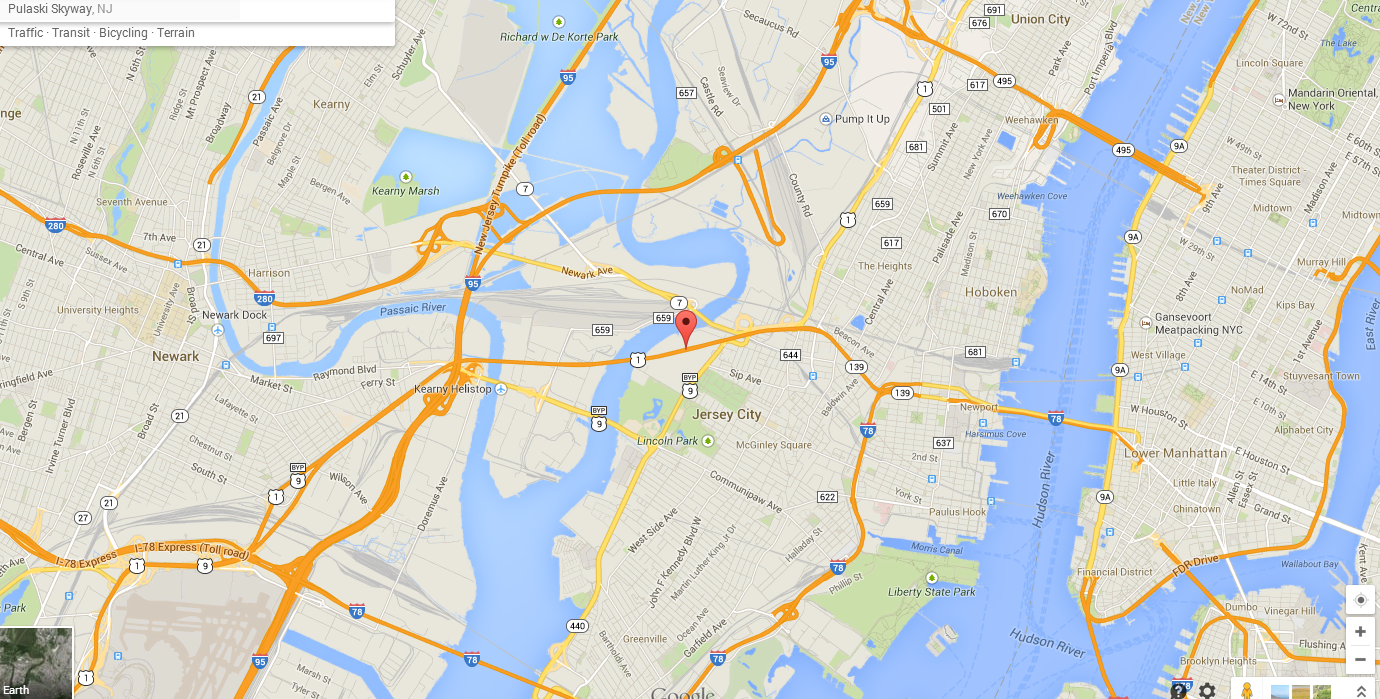
The Pulaski Skyway is one of the main thoroughfares into Jersey City and Manhattan. It’s a bridge that carries traffic from Route 1 and 9, and also serves a large portion of traffic exiting 95 (NJ Turnpike) on their way to and from the city. Starting this week, it’s going to be closed for two years. Expect a lot of traffic on surface streets as well as alternate routes as commuters try and make their way into the Holland Tunnel.

The bridge opened in 1932, and is in the final phases on a one billion dollar restoration that has been going on since 2007, and is slated to be completed in 2016. On this first weekday of closure, traffic has been light. This is most likely due to the impending Jewish Holiday, as well as the majority of schools not in session for spring break.  Expect about 2-3 weeks to get into a groove if this is your route, as commuters will get used to the new route options and detours


The most impacted areas are going to be as follows:
  • i95 N around Newark airport
  •   i78 will likely serve as the main bypass for many travelers; its only a few miles out of the way, and is wide enough to handle a good amount of extra traffic.
  •  Another traffic choke point is going to the rt. 1/9 bypass, AKA, Lincoln Highway.
  •  Outbound from Manhattan, commuters can expect heavier loads leaving to and from the Lincoln Tunnel as it hooks up with 95.
  • Coming down from the north, Rt.3 and 495 will see a lot of extra volume as commuters use the Lincoln Tunnel and go downtown via Manhattan surface streets.
  •  This will also cause additional delays on the West Side highway between the 50’s and downtown. Buckle up, the west side is going to be a mess for a while.
  • On the bright side though, Holland Tunnel traffic inbound is likely going to be significantly lighter until the pattern works itself out.

My route picks:
·         As always, use your traffic apps and listen to AM 88/1010 Wins for the most updated traffic, as conditions change, accidents happen and traffic flow varies greatly with the times of day.
·         Don’t go near the Lincoln tunnel
·         If you are coming from the north, use the GWB, and shoot down the Westside highway for downtown Manhattan access. Expects a mess down by the 30’s. If you are really ambitious, go a little further, and hop down the FDR to head downtown.
·         You might be tempted to take the Verrazano/ Goethalls up the Gowanus (278) to make it into Manhattan. I wouldn't do that due to the Gowanus’ propensity to back up. The belt isn't much better. Use this route only for queens, SI, Brooklyn and LI travel
o   You can also take 95 to 278, and take rt. 440 N to hook back up to 78.
·         The best route for now is probably going to be i78 for most weekdays.

·         A lot of this also depends on the signage they have up and how it affects those who aren't familiar with the territory. For weekends and Fridays, the Rt.9 bypass is going to be a good alternative to the i78 traffic that most weekend travelers will likely be directed towards. 

Tuesday, August 13, 2013

NY Metro Tolls Infographic

I apologize that this is from May, but it’s too cool to not post. And since its only 3 months old, the odds are strong that the tolls have since tripled.  In addition, this doesn’t reflect the reduced EZ Pass rates, which are only in effect on non-peak hours, on days that begin with T while the planets are aligned in the southern sky.
130408_outofny

Via @districtdrive via VerySmallAray (http://www.verysmallarray.com/?p=1567)


Tuesday, February 9, 2010

Electronic signs and the impatient commuter

Isn’t technology wonderful? It seems just a few years ago, we actually had to guess how long it would take us to go from point A to point B, and now we have these nifty electronic signs to tell us the approximate time to our destination – and sometimes they even work.

This entry is inspired by a road sign that I have been eagerly anticipating - the “average travel time to the Throgs Neck Bridge” (TNB) sign on the Grand Central parkway. This sign finally came on line at the beginning of this week, and to tell you the truth, I have mixed emotions.

On one hand, I am happy to have this reference just in case the Clearview (295) is totally backed up /flooded/on fire/closed/f. Everyone knows the Cross Island Parkway typically sucks, especially since the TNB caught on fire and the lanes were reduced, causing a daily clusterfuck of traffic for about 2 miles before the on ramp.

But then, I am angry that this sign is sharing my secret. The Clearview is an excellent road, and it’s typically the fastest way to the bridge because no one really wants to take it. Also, the CIP is about a mile beforehand, and drivers will typically encounter a wall of traffic between the two. But after seeing the sign, I think more drivers will move over to the Clearview because it’s shorter. I don’t want more cars on this road, and I hope they stay on the CIP. Here’s a sign I really would like to see.

I also found out an interesting thing today – this sign is accurate, and it is calculating distance from the sign, not from the start of the Clearview. So this sign actually takes into account the traffic beforehand. In order to do this though, it is important to note how these signs work- They respond to EZ pass tags or drivers, and then take an average. I am also pretty sure they have a minimum setting to confirm to speed limits. These “average travel time to…” signs are much more accurate than the old style of “traffic moving well to…” signs, that I have found myself sitting under at a complete stop more than one times.

But, like the red headed step child of New York it is, Jersey has to come out and screw it all up. They have one important sign. Just one – and that’s the one that says the average travel times for the different levels of the GWB. I have seen this sign working maybe twice in the past 8 months. And I know it works, so why isn’t it on? I mean, it was grossly inaccurate by at least 20 minutes in rush hour, but at least it was a good indicator of where you could waster more of your life sitting on that bridge.

Lots o’cars Broken Down since last post:  2001 Dodge Caravan, 2001 Nissan Altima, ~1997 Nissan Sentra, ~1997 Toyota Tacoma, 1999 ford Focus, 1994 Accord, mid 90’s Buick LeSabre